Trail highlights
- Civil War fort sites linked through eastern D.C. parkland
- Seven-mile Fort Circle Hiker-Biker Trail through wooded hills
- Class 1 pedal-assist recommended on mixed-tread NPS corridors
- Fort Dupont, Fort Stanton, and Fort Mahan historic landscapes
- Connections toward Anacostia Riverwalk and Rock Creek paved trails
Route Overview: Civil War Defenses Trail Network
The Fort Circle Trail network links Civil War-era fortifications that once ringed Washington, D.C.—a chain of earthen forts built to defend the capital during the Civil War. Today the Civil War Defenses of Washington sites are managed by National Park Service units including National Capital Parks-East and Rock Creek Park, with trails connecting Fort Stanton, Fort Dupont, Fort Davis, Fort Mahan, and other historic batteries across eastern and southeastern D.C.
The signature route is the seven-mile Fort Circle Parks Hiker-Biker Trail running between Fort Stanton and Fort Mahan through wooded hills east of the Anacostia River. Additional connections reach forts in Rock Creek Park's northern arc. Surfaces range from paved park roads to natural-tread hiking paths and the designated mountain-bike-friendly hiker-biker corridor.
This network offers a different D.C. riding experience—forest canopy, fort earthworks, neighborhood greenways, and skyline glimpses from hilltop batteries—far from the Mall tourist corridors. Total ridable distance depends on which fort sites you link; plan seven to ten miles for a representative loop.
E-Bike Access: Paved Roads, Hiker-Biker Trail, and Natural Surface Limits
NPS policy allows e-bikes where traditional bicycles are allowed, with operable pedals, motors under 750 watts, and no throttle-only riding on trails. D.C. motorized bicycle law applies: 20 mph motor cap, operators 16 and older. Class 3 e-bikes are not legal in the District.
Critical restriction: except for the designated Fort Circle Hiker-Biker Trail between Fort Mahan and Fort Stanton, bicycles are permitted only on paved trails and paved park roads within the Civil War Defenses sites. Natural-surface hiking trails throughout the fort network are closed to bikes—including most e-bikes. The hiker-biker trail is a mixed-tread corridor where mountain bikes are traditionally allowed; e-bike access here aligns with Class 1 pedal-assist models that match hiking-trail etiquette, and throttle operation is prohibited.
National Capital Parks-East manages southeastern fort sites; Rock Creek Park manages northern fort remnants. Each unit's compendium may specify speed limits—typically 15 mph on multi-use trails. Respect earthwork preservation rules: do not ride on fort ramparts or off established treads.
Highlights in the Fort Circle Network
Fort Stanton and Fort Dupont parks anchor the southeastern loop with deep forest, picnic areas, and interpretive signage about the Civil War defense system. Fort Mahan's hilltop position offers neighborhood views across Ward 7.
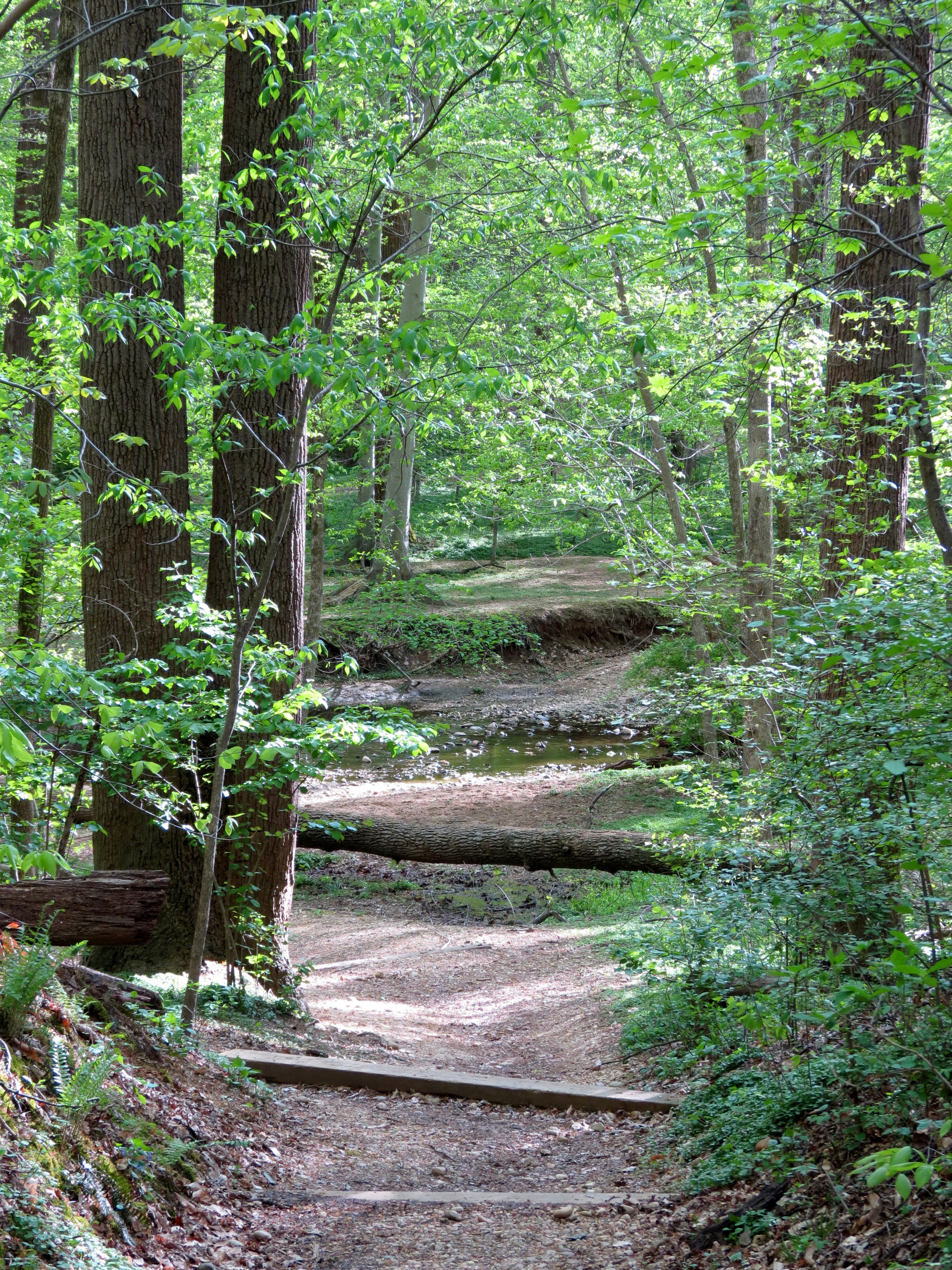
The hiker-biker trail passes through quiet woodland with stream crossings and bridge structures—recent NPS planning proposes connectivity improvements and bridge replacements across the corridor. Historic earthworks appear through the trees; dismount and walk if a section becomes too narrow or crowded with hikers.
Fort Totten, Fort DeRussy, and northern fort sites near Rock Creek connect to paved park roads and the Rock Creek Trail system for riders who prefer pavement over natural tread.
- Seven-mile Fort Circle Hiker-Biker Trail from Fort Stanton to Fort Mahan
- Fort Dupont, Fort Davis, and Fort Stanton parkland in southeast D.C.
- Civil War earthworks and interpretive history throughout the network
- Wooded hilltop riding with Anacostia neighborhood greenway connections
- Paved connections to Fort Totten and Rock Creek Park fort sites
Access Points and Parking
Fort Stanton Park offers parking off Erie Street SE with direct trail access. Fort Dupont Park has parking near the activity center off Randle Circle SE. Fort Mahan is accessible from Benning Road SE approaches.
Metro connections include Anacostia, Fort Totten, and Minnesota Avenue stations with on-street or park connections varying by fort site. Driving between forts is often necessary for a full tour unless you commit to the full hiker-biker corridor.
Northern fort sites near Fort Totten connect to the Fort Totten neighborhood via park roads. Verify current NPS maps—trail connectivity improvements may add or close segments during construction.
Riding Tips on Mixed-Surface Fort Trails
Use tires at least 40 mm wide with moderate tread for the hiker-biker trail; pavement sections suit standard commuter tires. Class 1 pedal-assist is strongly recommended—natural tread sections punish heavy throttle use and annoy hikers.
Yield to hikers always; this corridor is shared with foot traffic and occasional equestrians in connected parkland. Poison ivy and ticks are common off tread—stay on established paths. Do not climb fort earthworks; NPS prohibits riding on historic ramparts.
Navigation is trickier than on signed rail-trails. Download the NPS Civil War Defenses trail guide map before riding. Cell service is generally adequate but carry offline maps. Some neighborhood connector streets lack bike lanes—ride predictably on low-traffic residential roads between fort parks.
Seasonal Conditions
Spring mud slows the hiker-biker trail after rains; summer overgrowth narrows sight lines. Fall is ideal—dry tread, autumn color, and fewer mosquitoes. Winter rides are peaceful but daylight is short and natural sections may not be cleared of snow.
NPS construction on bridge replacements and connectivity projects may close segments—check National Capital Parks-East project pages. Heat and humidity in July and August are intense on exposed fort hilltops; carry extra water.
Nearby Trails and Connections
The Anacostia Riverwalk Trail lies west of the fort network—reachable via neighborhood connections through Anacostia Park. DDOT-authorized motorized bicycles are permitted on paved Riverwalk segments.
Rock Creek Trail and the Fort Totten area forts link the northern arc toward Georgetown. For paved-only e-bike riding, stay on park roads and the Rock Creek paved multi-use trail rather than natural-surface fort paths.
E-bike policy
Natural surface trails in NPS-managed forts may restrict throttle-assist e-bikes.
Access points
- Fort Stanton Park — Parking off Erie Street SE; southern anchor of the hiker-biker trail.
- Fort Dupont Park — Activity center parking off Randle Circle SE; forested fort site with trail connections.
- Fort Mahan — Northern anchor of the hiker-biker trail; hilltop views from Benning Road SE approaches.
- Fort Totten Area — Northern fort sites with paved park road connections toward Rock Creek Trail.
Seasonal notes
Spring mud and summer overgrowth affect the hiker-biker trail. NPS bridge and connectivity projects may close segments. Ticks and poison ivy active April through October. Fall offers the best mixed-surface conditions.
FAQ
E-bikes are allowed on paved park roads and paved trails, and on the designated Fort Circle Hiker-Biker Trail between Fort Mahan and Fort Stanton where bikes are permitted. Natural-surface hiking trails are closed to all bikes.